What to Do in Cañon City – Hiking
 Tunnel Drive – Easy
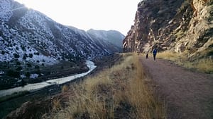
Stroll or bike along this gorgeous 3-mile stretch of dirt trail that offers panoramic views of the Arkansas River corridor. You’ll find yourself traveling through time as you walk through three tunnels – blasted through solid rock in the late 1800’s as a (now defunct) irrigation pipeline was laid through the Royal Gorge. This trail is relatively flat once you climb from the parking lot to the main trail. To find the trailhead, head west out of Cañon City, turn left onto Tunnel Drive (at the bend in the road as you’re leaving town). Follow the road until it dead-ends at the dirt parking lot.
 Canyon Rim Trail – Easy
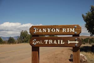
The early portion (first 1 mile) of the new Canyon Rim Trail is an easy hike through piñon forests along the rim of the Gorge. There are several stopping points along the trail that reveal awesome vistas of the canyon and surrounding areas. From Cañon City, take US Hwy 50 West to the turnoff for the Royal Gorge – CoRd3a. Continue on CoRd3A for 3.52 miles until you reach a pull off on the right side of the road, where you’ll see a covered picnic table. Park here and the trailhead is across the street.
Temple Canyon – Intermediate
This gorgeous trail follows Grape Creek as it winds through the canyon toward the Arkansas River. It is a lush, beautiful hike that terminates at an ancient rock formation that is said to be the site of Native American ceremonies and may even be haunted. The trail does have a fair amount of cacti and tall grasses, so sturdy footwear (that can get wet – you’ll cross the creek a few times) is a must. To reach the trail head, follow U.S. Highway 50 and turn south on 1st Street. Follow the signs to Temple Canyon Park. You’ll travel about 1 mile on 1st Street before you make a right onto Temple Canyon Road. Follow for 6.4 miles until you reach a pulloff after a few quick switchbacks. (You’ll see a bridge crossing the creek.) Follow the trail downstream. To reach the actual “Temple”, cross the creek when you see the Cottonwood Trees at the mouth of a side canyon about a mile down the trail.
(You can also ‘cheat’ and cut of a fair amount off the hike if you take a right around mile 5 of Temple Canyon Road. Park at the loop at the end and take the switchback trail directly down to the creek. You can access the mouth of the side canyon across the creek after about 400 meters. But you’ll miss some pretty cool scenery and some old railroad trestle ruins.)
What to Do in Cañon City – Biking
They call Cañon City the Banana Belt of Colorado, and our sunny weather sure seems to come in handy when it comes to riding our local trails.
Arkansas Riverwalk – Easy
 If slow and scenic is more your pace, the riverwalk provides over 5 miles of riverside trail that meanders through some of Cañon City’s historic landmarks, including the Robison Mansion, the Sante Fe Depot (now home to the Royal Gorge Route Railroad), the old Sells Lake property, and extends to Tunnel Drive in the east. Trailheads are easily accessed on Tunnel Drive, Sells Avenue (take 9th St. south and make a left on Sells after you cross the river), or at Makenzie Avenue.
Hogbacks Open Space – Intermediate to Advanced
Cañon City’s newest biking trail system is a fun, rolling mix of natural topography and manmade grades. The trail system offers users wide, dirt paths, singletrack, and some technical steep trails. Head up the Graneros trail to meet up with Old Skyline Drive, then opt to follow the paved road down to the bottom or ride the dirt trails back to the parking area. Beginner bikers will enjoy follwing “Greenhorn” – an easy double-track that runs north to south. To access the trailhead, travel north on 5th for 1 mile and turn left onto Skyline Drive. (A sign will say ‘no outlet’, and be mindful of cars traveling down as this is a one-lane driveway.) Park in one of the dirt parking lots and head north on your choice of trails.
 Oil Well Flats – Intermediate to Advanced
The views from the summit of the Oil Well Flats system of trails is unparalleled. This system of trails, a collection of singletrack and dirt roads, offers 7-12 miles of fantastic riding. There are open meadows, rocky sections, and beautiful creek beds on this fabulous ride. Challenge yourself with trails such as Anticline, which leads around the side of a mountain and points you toward the summit. From U.S. Hwy 50 in Cañon City, you can turn north onto Dozier Street (at Wal-Mart) or head North on Raynolds. Travel north on either road as both will curve to the left and intersect Field Avenue. Turn north (right) on Field and travel on this two-lane road for about five miles. It will join Fremont County Road 9 (also called Red Canyon Road) at a “Y” intersection. From here, continue north for 3.5 miles to BLM road #5940 which will be on your right. Head up the steep grade to the parking area on your right.
You can find a full trail map with even more options for exploring the Royal Gorge Region here.
Please remember that most trails do not have facilities, and all are pack-in / pack-out. See you on the trails!
